 JK Academy
 Std 6 Geog Ch 2 Let us use the Graticule – answers
Maharashtra Board Class 6 Geography Solutions Chapter 2 Let us Use the Graticule
Exercises
(A) Put a tick mark against the correct option in the space given:
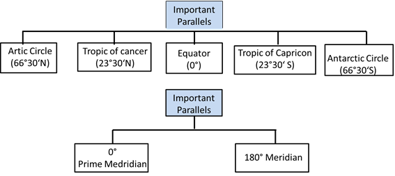
(1) 66° 30′ North parallel means:
(i) Arctic Circle
(ii) Equator
(iii) Antarctic Circle
Answer: Arctic Circle
(2) Which parallel bisects the earth?
(i) Tropic of Cancer
(ii) Tropic of Capricorn
(iii) Equator
Answers: Equator
(3) What is the angular distance of the Arctic Circle from North Pole?
(i) 66° 30′
(ii) 90°
(iii) 23° 30′
Answer: 23° 30′
(4) Where do the Prime Meridian and the equator intersect each other?
(i) Southern Ocean
(ii) Atlantic Ocean
(iii) African Continent
Answer: African Continent
(5) Up to which parallels from the equator can the sun’s rays be perpendicular?
(i) Tropic of Cancer and Tropic of Capricorn
(ii) Arctic and Antarctic Circles
(iii) North and South Poles
Answer: Tropic of Cancer and Tropic of Capricorn
(6) What would be the latitude of a place on the South Pole?
(i) 90° S
(ii) 90° N
(iii) 0°
Answers: 90° S
(B) Read the following statements and correct the wrong ones.
(1) While describing the location of a place mentioning the meridian is sufficient.
Answer: Wrong
Correct Statement: While describing the location of a place, we need to consider one parallel and one meridian.
(2) For describing the extent of a region, it is necessary to assume the latitude and longitude of the centre of the adjoining region.
Answer: Wrong
Correct Statement: For describing the extent of a region, we need to consider two parallels and two meridians at the extreme ends of the same regions.
(3) Location of a road can be described only with a map.
Answer: Wrong
Correct Statement: Location of a road can be described with latitude and longitude of a point.
(4) 0° East meridian and 180° East meridian.
Answer: Wrong
Correct Statement: 0° meridian and 180° meridian.
(5) The extent of a road or a river course is described with the help of the latitude of a point in the source and the longitude of a point at the end.
Answer: Wrong
Correct Statement: The extent of a road or a river course is described with the help of the latitude and the longitude of a point in the source and also at the end.
(6) 8° 4′ N parallel to 37° 66° N parallel is the correct description of a location.
Answer: Wrong
Correct Statement: 8° 4′ N parallel to 37° 66° N parallel is the incorrect description of a location.
(C) Find the locations of following cities from a world map, a map of India or a Globe and write down the latitude and longitude of each of them.
(1) Mumbai
(2) Guwahati
(3) Srinagar
(4) Bhopal
(5) Chennai
(6) Ottawa
(7) Tokyo
(8) Johannesburg
(9) New York
(10) London
Answer:
| Place | Latitude | Longitude |
| Mumbai | 19° 00′ N | 72 48’ E |
| Guwahati | 26° 12′ N | 91 48’ E |
| Srinagar | 34° 05′ N | 74 50’ E |
| Bhopal | 23° 18′ N | 77 24’ E |
| Chennai | 13° 06′ N | 80 18’ E |
| ottawa | 45° 27′ N | 75 42’ W |
| Tokyo | 35° 45′ N | 139 45’ E |
| Johannesburg | 26° 10′ S | 28 03’ E |
| New York | 43° 00′ N | 75 00’ W |
| London | 51° 31′ N | 0 7’ W |
(D) Find and write down the extent of the following. (Check them on the internet/ mobile).
(1) Maharashtra (State)
(2) Chile (A country)
(3) Australia (A continent)
(4) Sri Lanka (An island)
(5) Trans Siberian Railway of Russia (Starting point – St. Petersburg, Terminal Point -Vladivostok)
(1) Maharashtra (State)
Answer: 20° 00′ N / 76° 00’E
(2) Chile (A country)
Answer: 35° 00′ S / 72° 00’W
(3) Australia (A continent)
Answer: 10° 30′ S to 43° 39′ S – 113° E to 153° E
(4) Sri Lanka (An island)
Answer: 7° 30′ N / 80° 50′ E
(5) Trans Siberian Railway of Russia (Starting point – St. Petersburg, Terminal Point-Vladivostok)
Answer: 59° 55′ N / 30° 20′ E – 43° 10′ N / 131° 53’ E
E. Draw important parallels and meridians in the figure given below and label them with appropriate angular measures. (Use the protractor.)
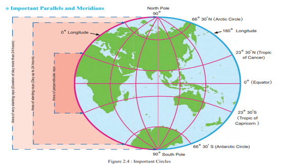
F. Write the important parallels and meridians in the following table: Answer:
1. The Earth and the Graticule
3. Comparing a Globe and a Map; Field Visits
4. Weather and Climate
5. Temperature
6. Importance of Oceans
7. Rocks and Rock Types
8. Natural Resources
9. Energy Resources
10. Human Occupations